The Wroxton Fingerpost – erroneously pointing the way from the deep past.
‘Long Walks & Anarcho-Primitivism’, Part 5:
Ancient Roads and the Wroxton Fingerpost
There are events and periods of history that are not talked about; they raise difficult, political questions about that history. Viewing how the past has created the world as it is today, with all its perceived faults, can be a journey into that unspoken, ‘taboo history’.
There are events and periods of history that are not talked about; they raise difficult, political questions1 about that history. Viewing how the past has created the world as it is today, with all its perceived faults, can be a journey into that unspoken, ‘taboo history’.
The beauty of walking is that you can slowly meander through the countryside, and that slow speed enables you to see more of the world as you pass by. Not just the immediate sense of the place, but the visible clues to the world as it was, mapping how it evolved into the world as it is today.
Those patterns in the landscape are intimately tied to the history of the nation. Much of this history lies in plain sight; just waiting to be discovered if you look for it. Even seemingly innocuous anomalies, in most cases, have some deeper reason for their existence; and if you ask those difficult questions, you can discover a whole new perspective on the landscape around you.
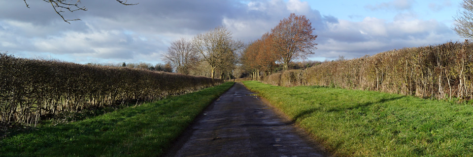
Take a road seemingly in the middle of nowhere, for example. A little the single-track road2, going pretty-much nowhere. Running along a far wider gap between the adjacent hedgerows, it obviously was more important in the past. But perhaps the biggest give-away is the change in ground levels along its length: The surface of the land hereabouts is missing!
In the last century this area, to the North and West of the village of Wroxton, near Banbury, has been reshaped by Ironstone quarrying3. First for the steel industry, which was removed via a railway line; then construction stone, which is now removed by lorry – most recently, for the HS2 project, just a few miles away.
This history of quarrying exercises people’s angst about “the destruction of the countryside”. The fact is, the scale of these changes today are nothing compared to the change forced by the Agricultural Revolution4 three hundred years ago. It fundamentally redefined people’s relationship to the land, and access to the land; and in the process, created Britain’s modern urban landscapes, and its relatively exclusive, empty countryside.
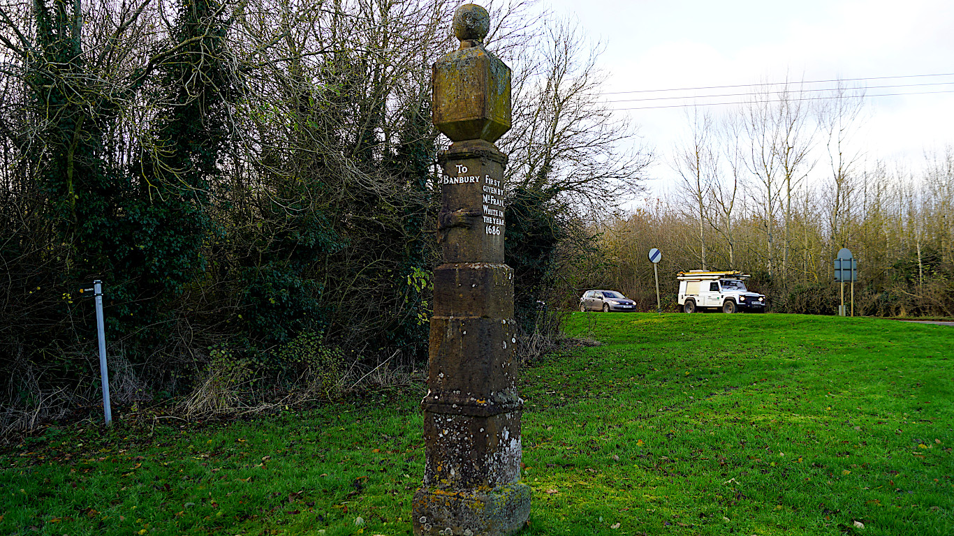
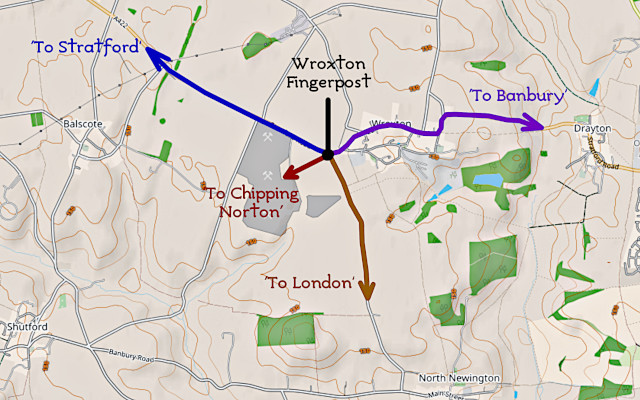
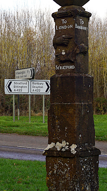
A short distance away, from that little road and the stone quarries, is the ‘Wroxton Fingerpost’5.
Most people speed past it along the A422 Banbury to Stratford road. Even if they notice the monument, they may not realise what it is. When you get up close, though, if you really think about it, it’s telling you a story which – in the modern context – seems to make no sense.
The story of the ‘Wroxton Fingerpost’ shows how the world around this ancient stone has been reshaped by political and economic forces, as great as anything happening today; ones which are still at work, in the stone quarrying, and the intensive industrial monoculture of the surrounding fields.
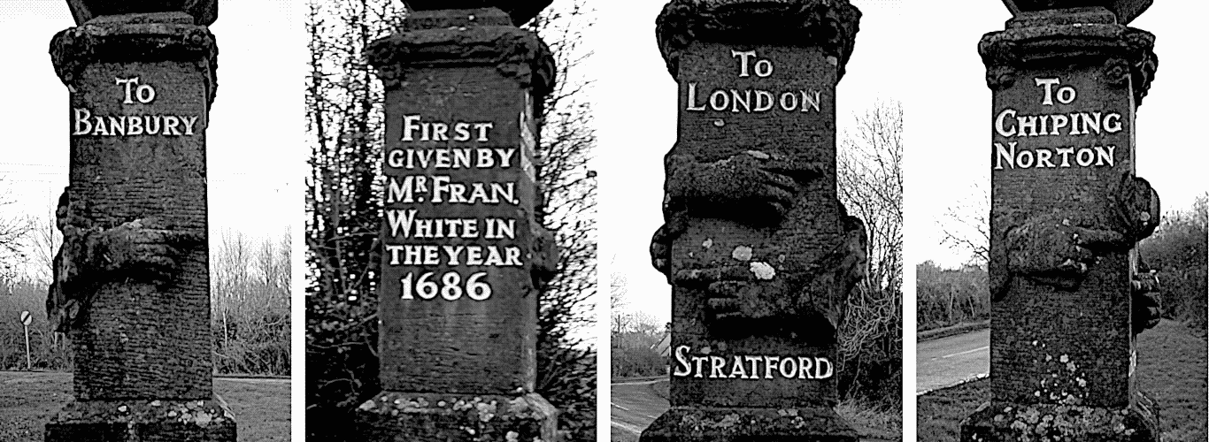
The stone is square, with an inscription on one side, and on the other three sides, carved fingers which point the way to their respective destinations:
On face without a finger, on the village side, the inscription reads, “First given by Mr. Francis White in the year 1686”.
White had been a steward to the powerful North family – the Barons of Guilford6 – who bought the nearby Wroxton Abbey7 in 1677. Little is know of White, except that he gave this monument to the village.
It says “First given”, because there is some dispute as to how authentic this stone is. It may be the remains of the one erected in 1686. It may have been replaced when the North family created their landscaped park almost a century later. What we do know is that in the 1970s, the stone was completely reworked to hide two centuries of graffiti – removing over a centimetre of stone off of each face, and re-carving the fingers and inscriptions.
On the south-east face, the finger points, ‘To Banbury’. Cast your eye across to the road, and the modern sign and it points there too. Nothing wrong there.
On the the south-west face, one finger points left, ‘To Stratford’. Well, that’s fairly obvious too. But above it the finger points right, down a single-track road, ‘To London’. How can that be? The main road leads to Banbury, but this little road winds down narrow lanes to nowhere.
Finally, on the north-west side, the finger points, ‘To Chipping Norton’ – across the nearby fields. Not only is there no road there, but that’s not even the way towards Chipping Norton!
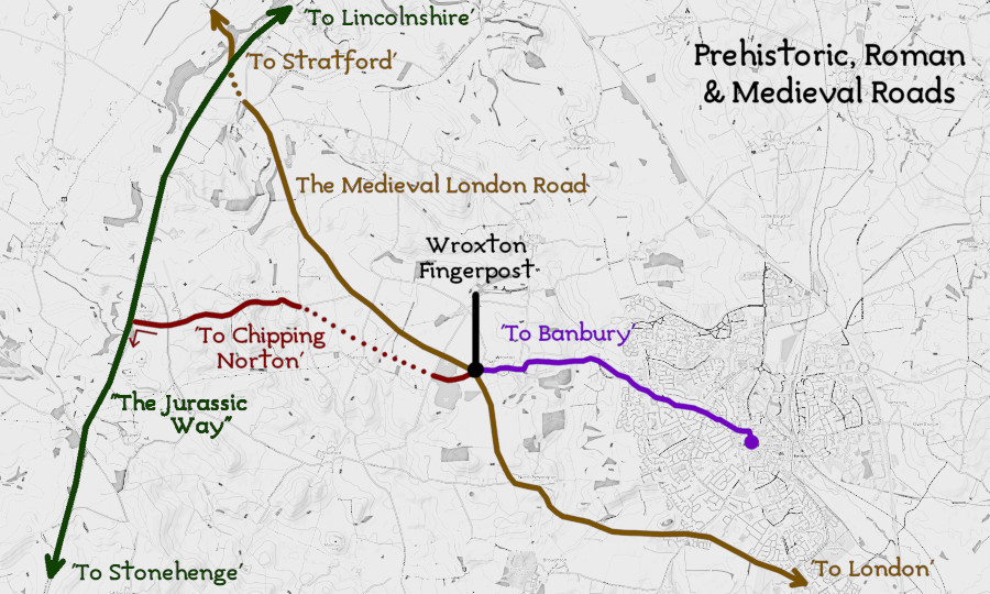
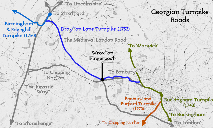
What this stone is tells you is the five-thousand-year history of how people have moved across this landscape. To understand that, we need to look at a map of the local area.
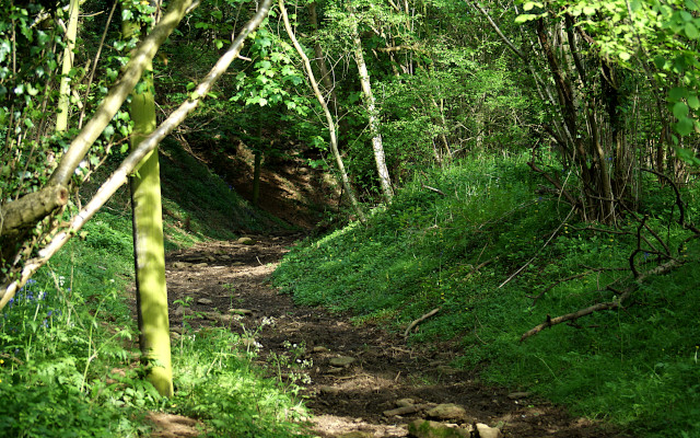
The continuation of the Medieval road down ‘King John's Lane’ at Edgehill
The Medieval road from Stratford to London did not pass through Banbury. It didn’t even follow the A422.
North-west from here, near Upton House, it swung north, down the escarpment along King John’s Lane8, and on past Edgehill’s Civil War battlefield to Kineton. Over centuries of use its path shifted as erosion required its course to be re-cut on the steep hillside. Those changing routes are still visible as depressions in the wooded ground surface today.
The wide lane with the narrow single-track road nearby was a parallel Medieval road, and may have been the more major of the two. Many roads in this area had their origins in Roman times, when the Ironstone was worked9 to produce pig iron – in the process clearing trees from the local landscape to create the charcoal necessary for the iron kilns, a practise that continued in local villages until the Nineteenth Century.
In the London direction, along the narrow lane, the road joined the Roman ‘Salt Way’10 near the village of North Newington. This ran from Droitwich, crossing the river at Stratford, then taking a straight line to Broughton and Bodicote, where it crossed the River Cherwell. From there it went to Buckingham, connecting with the road to London along Roman ‘Watling Street’11.
The finger pointing into the field towards Chipping Norton follows an even more ancient route.
Along the line of the Ironstone escarpment was an ancient ridgeway – which some have called, ‘The Jurassic Way’12, as it follows the line of the Jurassic-age rocks down from Lincolnshire. Recent archaeological research13 suggests that five thousand years ago, people were driving their livestock along this route from the North East of England, down to Avebury and Stonehenge for festivals. From here, that route runs south-west, crossing ‘The Cotswold Ridgeway’14 near the Rollright Stones circle, and then carrying on to Chipping Norton.
Today the route out into the field survives as a public footpath. Three hundred years ago, the quickest way to Chipping Norton would have been to follow that path, through the villages of Balscote and Shenington, and then turn left down ‘The Jurassic Way’.
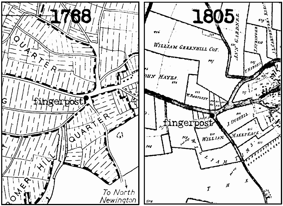
During inclosure15, which took place around 1800, these open fields, along with the common land on which local people subsisted, were enclosed with hedges – creating the landscape we see today. Taking away the common land took away many people’s means of survival, and they would have been forced to move from the land into the growing urban centres – like Birmingham, where this Medieval road ultimately runs to.
If we look at this map of Wroxton in 1768, you can see that there are many roads west from the village which link to an extensive open field system. This field system had been established in the Thirteenth Century by the Augustinian priory. That lasted until it was ‘privatised’ by Henry VIII, and parcelled out to his friends in the Sixteenth Century. Locally that was the Pope family, who in turn gave the land to found Oxford’s Trinity College16; and sold the remains of the priory to the Barons of Guildford, to be their country estate.
Locally, with their livelihood taken away, the inclosure of the local parishes swelled the ranks of the landless poor. This led to the Swing Riots17 of the 1830s, and to the establishment of the new, larger Union Workhouse18 on the road into Banbury – which, more than anything else, created the boundaries of what today the local tourist lobby call, ‘Banburyshire’19.
Along with that inclosure of the land, around the same time we see the creation of the first national road system since the Roman era – the turnpike roads20. These roads were better than the Medieval roads. They had a compacted stone surface to support the cart and carriage wheels. The big difference was that the turnpike trusts, created by Parliament to maintain them, charged a fee for their use. In effect, Parliament created private corporate monopolies, and people had to pay the price.
The first turnpike road to Banbury from London arrived in 1743. It followed the route of Roman Watling Street to Buckingham, and then along the Roman Salt road to Banbury. From there it followed the Medieval ridge route towards Warwick.
Due to the way Parliament and local government operated, turnpikes ran to and from the county border. Birmingham was then in Warwickshire. For this reason, in 1750, the Birmingham turnpike ran to the Warwickshire border, at Edgehill, but could go no further. Rather than use the Medieval route, as often was the case with the new turnpikes, they cut an engineered track up the escarpment at Sunrising Hill – which forms the route of the modern road today.
In 1753, the Drayton Lane turnpike connected these routes together, running past the ‘Wroxton Fingerpost’. Then finally, making the ancient ‘Jurassic Way’ obsolete, the Banbury, Chipping Norton and Burford turnpike opened in 1770.
Rather like modern motorways, the coming of the turnpikes would completely change how people moved around the local landscape.
The Turnpikes and the Centralisation of Political Power
In ancient times, local trackways had linked Lincolnshire and The Wash to The Cotswolds and the Wessex Downs, reflecting the movement of people crossing the North Sea from Europe.
The coming of the Romans led to the creation of an occupying administration, centred on a few major towns such as London and York. Their roads network reflected the dominance of these administrative centres.
In early Medieval times, with the country fractured into different kingdoms, there was no central authority. Roads went by the most direct route, following minor and regional Roman roads. Even the Norman invasion didn’t really redraw the roads map of Britain.
With the coming of the turnpikes, though, Britain became London-centric – with both the roads, and the carriage services which ran along them, all focussed on the growing political power of London and the south-east. This was also the time in which the modern, highly centralised British state established itself, and its dominance over the first the people’s of the British Isles, and then the empire.
Old and new ways from ‘The Wroxton Fingerpost’
Today’s modern road network – created in its current form between 1919 and 1936 – still echoes those ancient routes:
The A422 into Banbury roughly follows that Medieval road, going through Buckingham to join Roman Watling Street, the modern A5, near Milton Keynes.
The A41 still follows the mainly Roman roads towards London, though these days it’s importance has been demoted by the arrival of the M40.
And the A361, running to Chipping Norton, follows the route of that prehistoric road from the Leicestershire border down to Avebury.
Generations of my family have lived in this area. That makes it easier for me to see these relationships, because when I was growing up these geographical boundaries were part of my life. Is this what it means to be ‘indigenous’; to know the story of the local land? To know how that ‘deep creation story’ of a small area is intertwined with your own creation story.
Banbury is not unique. Other places have their stories to find too. If you regularly walk get to know the land, especially if you peer into its strange and unusual features, the history of why the land is as it is will fall into your lap. You just need to get out there, and look in those neglected corners of fields and road verges.
In today’s mobile world, first created in that Georgian Revolution of land inclosure and new roads, people are severed from the land – and thus they are severed from their own ‘natural history’. Finding that history, and if possible finding that identity within the landscape, or at least a small part of it, can allow you to find your own place in this complex web of historic political and economic change.